| by | Israel Kashani, The Ohio State University and Technion - Israel Institute of Technology, kashani.i@gmail.com, |
| Pawel Wielgosz, The Ohio State University and University of Warmia and Mazury in Olsztyn, Poland, | |
| Dorota Grejner-Brzezinska, The Ohio State University. |
14 September 2004
INTRODUCTION
A network-based approach to instantaneous (single-epoch) long-range
real-time kinematic (RTK) GPS positioning has been implemented and tested
in the Multi Purpose GPS Processing Software (MPGPS), developed at The
Ohio State University in corporation with the Technion Israel Institute
of Technology and the University of Warmia and Mazury in Olsztyn, Poland.
The implemented approach is based on atmospheric corrections derived from
reference station GPS observations that support the rover positioning.
The use of this approach, in GPS kinematic positioning, significantly increases
the distance, over which carrier-phase ambiguities can be recovered to
their integer values. The positioning algorithm is based on a single baseline
solution aided by network derived atmospheric corrections to support the
ambiguity resolution. The motivation behind this research, supported by
NOAA/NGS and the Survey of Israel (SOI), is to develop and evaluate the
state-of-the-art methodology and algorithms for centimeter-level long-range
instantaneous RTK GPS, suitable for geodetic, surveying and navigation
applications. Instantaneous ambiguity resolution (AR) has several advantages
over the on-the-fly (OTF) method; it is resistant to negative effects of
cycle slips and can provide centimeter-level positioning accuracy immediately,
without any delay needed for initialization for short distances, as required
by the OTF technique (Bock, 2003; Kashani et al., 2003; Wielgosz et al.,
2003). Since every epoch is virtually independent, loss of lock, a cycle
slip, or a change in the tracked satellite constellation does not introduce
additional complications to the data processing.
NETWORK-DERIVED RTK CORRECTIONS
The atmospheric RTK corrections provided by the network to the roving
users include tropospheric delay (non dispersive) and ionospheric delay
(dispersive). The tropospheric delay is parameterized as a Total Zenith
Delay (TZD) - an undifferenced delay in the zenith direction for individual
stations. The Zero Difference (ZD) ionospheric delays are estimated in
two steps; in the first step the delays are parameterized as double-differences
(DD), and then in the second step they are decomposed to the ZD delays
for specific station-satellite pair. The network algorithm uses the pseudorange
and phase observations while all the reference station coordinates are
considered known (Kashani et al., 2004). A generalized least squares solution
(GLS) was applied to solve the underlying mathematical model (Felus, 2004).
The flexibility of this model allows an easy implementation of different
stochastic constraints, weighted parameters or fixed constraints, in instantaneous
as well as in batch or sequential solutions. The Least-squares AMBiguity
Decorrelation Adjustment (LAMBDA) is used in order to fix the ambiguities
to their integer values. The validation procedure used is the AR success
rate, which is the probability of estimating the correct integers (Teunissen,
2000; de Jong and Tiberius, 1996).
RTK ROVER POSITIONING
The RTK rover positioning can operate in both single-baseline and multi-baseline
modes in a two-step procedure. In the first step, DD ionospheric delays
and TZD are provided by the network to initiate the rover positioning solution.
The OTF technique with accumulation of a few epochs is applied to start
the system and to validate the initial AR. Once the ambiguities were resolved
in the first step (fixed and validated), the instantaneous solution is
applied afterwards (the second step). To enable the instantaneous ambiguity
resolution, the DD ionospheric delays from the previous correctly resolved
epoch are provided to the rover solution instead of the interpolated ones.
The latency of 3060 seconds of the DD ionospheric delays is acceptable,
depending on the ionospheric conditions, the reference network scope and
the baseline length. The RTK algorithm uses the double-frequency pseudorange
and phase observations. The LAMBDA method is used as the AR method as in
the network solution. However, the F-ratio test and the W-ratio were applied
in the rover solution in order to validate the AR.
EXPERIMENTAL RESULTS
GPS observations from the Ohio CORS collected on August 31, 2003, with
a 30-second sampling rate were used in the tests. The data were collected
in two sessions: 08:0009:00 UT (34 am local time), which demonstrate
the lowest TEC, and 17:0018:00 UT (12 pm local time), during the highest
TEC values. The map of the reference network and an example of the COLB-MCON
baseline solution is presented in Figure 1. It should be noted that COLB
station served as a rover and did not contribute to the atmospheric corrections.
The instantaneous solution starts after 3-epoch initialization, and is
carried through to the end of the session. Table 1 refers to the baseline
solution illustrated in Figure 1, and contains the estimate statistics.
The ambiguities were fixed to their integer values with a 100 percent success
rate. The analysis was performed in the post processing mode, while the
algorithm is suitable for real-time application. Naturally, for the real
RTK implementation, the issue of communication and the computing power
at the rover station must be addressed properly.
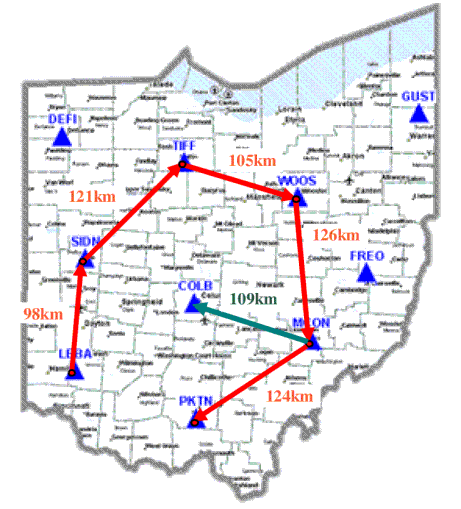
Fig. 1: Map of the test area: network (red) and COLB-MCON baseline
(green).
Table 1. Statistics for baseline COLB-MCON (110 km). Solution
with 30-second latency of the atmospheric corrections. The AR success rate
was 100 % for both sessions.
| Night Session
mean [m] |
Night Session
std [m] |
Day Session
mean [m] |
Day Session
std [m] |
|
| dn | -0.004 | 0.007 | 0.005 | 0.008 |
| de | 0.008 | 0.008 | -0.005 | 0.008 |
| du | 0.025 | 0.025 | -0.032 | 0.028 |
SUMMARY
The feasibility of centimeter-level instantaneous RTK GPS over 100 km
distance was demonstrated when atmospheric corrections are provided to
the rover by the local reference network stations, followed by the use
of previous-epoch ionospheric delay. Based on the results presented here
and in Kashani et al. (2004), it can be concluded that the methodology
and the algorithms developed for the long-range instantaneous RTK module
in the MPGPS software can provide millimeter to centimeter-level horizontal
rover position and centimeter-level vertical one, for baselines over 100
km. However, more tests are planned including longer data spans and different
ionospheric conditions to fully assess the performance of this method.
REFERENCES
Bock Y., de Jonge, P., Honcik, D. and Fayman, J. (2003): Wireless Instantaneous Network RTK: Positioning and Navigation, Proc. ION GPS/GNSS, September 912, Portland, OR, pp. 13971405
Felus, Y.A., (2004): Application of Total Least Squares for Spatial Point Process Analysis, Journal of Surveying Engineering, Vol. 130, No. 3, pp. 126133
de Jonge, P.J. and Tiberius, C.C.J.M. (1996): The Lambda Method for Integer Ambiguity Estimation: Implementation Aspects, LGR Publication No. 12, August, pp. 1-49, (PDF file, 376 kB)
Kashani, I., Wielgosz, P., and Grejner-Brzezinska, D.A. (2003): Datum Definition in the Long Range Instantaneous RTK GPS Network Solution, Journal of Global Positioning Systems, Vol. 2, issue 2, 2003, (PDF file, 436 kB)
Kashani, I., Grejner-Brzezinska, D.A., and Wielgosz, P. (2004): Towards instantaneous RTK GPS over 100 km distances, Proc. ION 60th Annual Meeting, June 79, 2004, Dayton, Ohio, pp. 679-685,
Teunissen, P.J.G. (2000): On the GNSS Integer Ambiguity Success Rate, Lustrumboek Snellius, The 5th Element, pp. 103-108, (PDF file, 522 kB)
Wielgosz, P., Grejner-Brzezinska, D., and Kashani, I. (2003): Network Approach to Precise GPS Navigation, Proc. ION Annual Meeting, June 2325, CD ROM, pp. 397403